The idea behind this site is to share as much visual content as possible. I carry a GPS recording DSLR and an HD Camcorder. My first priority is photography, but I take out the camcorder when I can.
Trail notes are designed to help hikers and runners learn more about a specific hike taken. Here is what you'll find here:
Trails Taken - Route of the hike
Mileage- How far was the hike (I wear a GPS enabled watch, which records distance traveled, pace, elevation changes, etc. It works great when I remember to turn it on. Occasionally I lose the satellite signal, so please take these mileage numbers as an approximation, not necessarily an exact distance.)
Trailhead - Where did I start and finish, location of bathrooms, water, etc...
Notes and Impressions - I usually carry a small digital recorder to record voice notes, and enter the transcript here.
I'll include the images here as well. If I've taken video, you'll see it at the end of the notes.
This hike is located in the Marin Municipal Water District watershed, up near Fairfax. The land is lush and vibrant, full of streams, waterfalls, a huge variety of trees, mosses and ferns. You can soak up nature in this 3.02 mile (round trip) hike, and leave calm, refreshed and inspired.
Take Bolinas Road in Fairfax to Mile Marker 8.13. It's just past the narrow bridge you'll drive over. Park on the side of the road. Cataract Trail starts here.
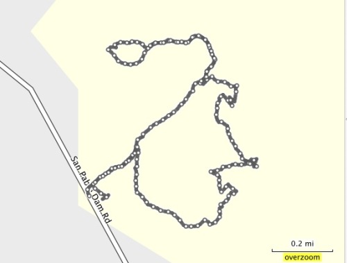
Here is the Trail Map. You'll see the Cataract Trail at the southwest part of the map, at the lower part of Alpine Lake.
There are toilets and picnic tables in Laurel Dell, which is a great setting to rest, eat and contemplate.
Route: From the trailhead, take Cataract Trail to Laurel Dell. Hang out in Laurel Dell, then, take Cataract Trail back to the trailhead. Total distance: 3.02 miles.
Of course, use the map if you want to expore more of the watershed. I definitely plan on going back.
Here are a few scenes:
Lush trails next to the water
Waterfalls
Trail has stairs, but they are well maintained
Beautiful bridges and streams
Land of the Lost?
Lush and vibrant
This place has tremendous character...very worth a visit!
Big Bear and Bird Trails are in the Anthony Chabot Regional Park, and I accessed them via the Big Bear Staging Area on Redwood Road.
Big Bear is a .38 mile loop with a gentle climb. It's got some nice canopy and a wide trail. It's not much for exercising, but you can use it more as a place to wander and contemplate.
Bird Trail is a pretty but narrow trail, with wild raspberry bushes and poison oak reaching out to grab you as you hike through. However, if you're careful, this short little trail (.34 miles) has some nice little bridges and meanders along a stream.
What better way to start out the new year than with a hike? I had some new camera equipment to test out, and I wanted to find a nice canopy trail to photograph. I checked my EBMud map and came across the Ramage Peak Trail, which starts at the Chabot staging area on Redwood Road, near Castro Valley.
The trail marker at the start of the hike says you're on the Rocky Ridge Loop Trail, but the map says it's Ramage Peak Trail. If you travel the whole loop, you'll hike 7.4 miles. I just went in about 1 mile, and returned. I just wanted to take some pictures, but kept going until the canopy opened up. I'm saving the rest for another day...
If you just want a nice and picturesque meditation walk, hike this short section of the Ramage Peak Trail. Take your time, and enjoy the beautiful Oaks and Bay trees. Start at the staging area, and catch the trail as it starts off on the right of the Christmas tree farm.
Kennedy Grove Regional Recreation Area is a nice place to bring visitors for a combination hike and picnic. The picnic area is nestled under towering Eucalyptus trees, has a nice, clean bathroom, and a big area to romp around in. Before you eat, you can take a hike on the Sea Foam trails, and see some beautiful Oaks and Bay trees.
This is a small park with only a few trails. My route started at the parking area. I followed the Laurel Loop Trail to Lower Sea Foam Trail, then took the Upper Sea Foam Trail up the hill to the oak grove. Take some time to enjoy the oaks. The climb up is the only real strenuous part of this hike. I followed the Upper Sea Foam Trail to the Kennedy Creek Trail. You can take a left here, and go back to the picnic area. Or, you can continue on and take the Black Oak Loop. This short little loop takes you through even more beautiful and established Oaks.There is a picnic area in these Oaks too.
Summer hikes in the East Bay can be challenging if you hike mid-day. Even the birds grow quiet, prefering to hang in the shade and watch weary hikers walk on by. One way to avoid the fatigue and dust of a hike in the heat is to start out early. It's also a great way to observe the beautiful morning light. Dawn is when the birds start chattering, and you'll have an opportunity to see them hunting for their breakfast.
This hike is a beautiful combination of rolling, oak studded hills, canopied trails and spectacular views. It starts at the Reliez Valley Staging Area, in Lafayette. (Just up the street, opposite, is the serene and welcoming Buddha Gate Monastery, well worth a visit.)
The parking area at the Reliez Valley Station is small, so get there early enough to grab a spot. Start out on the Blue Oak Trail, just past the gate.
The trail splits, but reconnects later. I took the single track trail on the left to avoid any bikers.
The early morning sun gave a golden glow to the hills and Oaks as I climbed up the Blue Oak Trail.
The trail here opens to a wider fire road. You'll have views of rolling hills and the local suburbia, and even though this trail gets busier during the day, at this time of the morning it was peaceful and quiet. In the high grasses, I saw a family of Wild Turkeys, and they scattered as I moved past them.
Self Portrait on the Blue Oak Trail:
At 1.26 miles - Take a Left on to Spengler Trail. Spengler splits here, but keep left for this trip to Briones Peak.
1.57 miles - Right on to Table Top Trail - On your climb to Briones Peak
From Table Top Trail, you'll see expansive views of the Carquinez Strait, and the Benicia/Martinez Bridge. You'll see this view again at the top of Briones Peak.
1.94 miles - Keep Right on to Briones Crest Trail to Briones Peak
2.14 miles - On your Right is an unmarked little path to Briones Peak. Follow this path for a short bit to a fence. On the other side of the fence is a nice bench with a view of the Carquiniz Strait. If you're up to it, climb over the bars, sit and have a nice meal/snack/beverage.
Path to Briones Peak
View from Briones Peak
Return back down and head back the way you came. At the Table Top/Briones Peak intersection, take a right on to Table Top Trail. This will take you on a nice, senic loop, but eventually leads back to the staging area. Or, you could call it a day and return the way you came. If you rested at Briones Peak, and had a snack, take the loop. It's great exercise.
Scenes from the Loop:
Follow Table Top, and keep bearing left as you hike back. This loop is going to take you back to the Table Top/Spengler split. You'll follow Table Top on this loop, and eventually take a Left back on to Spengler.
At about 4.72 miles, you'll be back at the Table Top/Spengler split. Continue Right on to Spengler. Follow Spengler until you get back to the first split.
Take a Right here, on to Blue Oak Trail. This will take you back to the Reliez Valley Staging Area.

 Lush trails next to the water
 Waterfalls
 Trail has stairs, but they are well maintained
 Beautiful bridges and streams
 Land of the Lost?
 Lush and vibrant
 This place has tremendous character...very worth a visit!
 East Bay Trails