The mission of East Bay Trails.com is to showcase trails and nature in the San Francisco East Bay and around the world. I believe the path to health and wellness lies in exploring nature, especially through hiking. Through photography, video, news and information, my goal is to share what I've seen so that people become motivated to explore nature, and through that effort, become healthier.
Lagunitas Creek is one of the last strongholds for central California coast Coho salmon. As part of their spawning process, they enter the creek from the ocean. Their migration starts in October, and they swim upstream to spawn. Peak spawning is in December, and lingers until February.
Baby Salmon hide under log jams for protection. The Marin Water District has created these artificial log jams to help protect the salmon.I walked along the creek to the dam, and then turned around and climbed up Shafter Grade. This is a nice hike, with views and the ability to go deep in to Marin Watershed lands, and ultimately to the coast.
Keeping an eye on me.
My trip was quick, I just wanted to scout this location and take some pictures. I will explore this in more detail in the future, but I wanted to share this with you now in case you're interested in watching the salmon spawn.
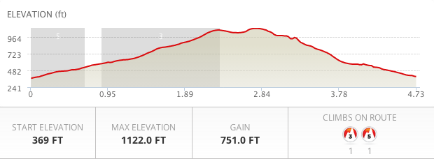
Bothe - Napa Valley State Park is accessible right off Highway 29 and just down the street from downtown St. Helena. You can get there early, do this hike, a pleasant and rewarding 4.73 miles, and finish with a meal and great local wines.
As of this writing, the park access fee is $8. You can park right near the trailhead, and you'll see this sign at the start of the trail.
Starting here takes you on to the trails, but first, cross a paved narrow service road and go by a few other buildings. They have a few Yurts set up too. You can rent them for camping if you don't have your own tent.
As the trail map shows, there are not a lot of trails here. But you'll see a great variety of trees in this park, including coastal redwoods, oaks, maples, madrones and hazelnut.
Even late in the summer the forest looked lush and green.
Redwoods are abundant here, but not towering. Like most of the local redwood forests, the giant trees were logged in the mid 1800's to provide the structure for San Francisco.
In the fall, Ritchey creek is mostly dry, with a moderate trickle of water flowing through the rocks.
Continue on the Ritchey Canyon Trail, crossing the stream here:
Cross the stream and continue on the Ritchey Canyon Trail when you see this sign.
Now Ritchey Creek is on your left, as you continue to hike through the bays, oaks and redwoods.
You'll pass a boarded up house, and eventually a barn. I paused and hid a bit so I could photograph some of the locals. Walk past this barn and continue on the trail.
Continue on Ritchey Creek Trail.
The forest becomes more dense, and the noise from the campground and highway 29 traffic starts to dissipate.
A little madrone makes its appearance.
This trail is open to equestrians, so watch where you step.
Continue on Ritchey Canyon Trail
Next, take the South Fork Trail and cross Ritchey Creek again.
The bridge across Ritchey Creek.
The trail goes deeper in to the redwood forest. The trail narrows and the climb gets more intense.
Enjoy your climb through the redwoods, and eventually you'll see this sign. Here, you'll want to go left on to Coyote Peak Trail.
Nice patch of redwoods in this area.
You'll go through more redwoods, and then the trail opens up a bit as you climb. You'll start to see quite a few vibrant and twisted manzanitas.
Almost at the top. When you see this sign, take a right and start your climb to the top of Coyote Peak.
There are a few old manzanitas here, as well as some madrones.
Once you get to the top of Coyote Peak, you'll only be able to see the valley through gaps in the trees. However, this is a nice place to rest and hydrate.
Take some time to explore the manzanitas and madrones on your way down from the peak.
As you climb down from the peak, go right at the trail split, instead of returning the way you came. You'll visit a forest with more oaks, bays, redwoods and maples.
More redwoods start to appear on the way back.
There is a spectacular Oak forest near the end of this hike.
When Coyote Peak Trail ends, take a right on to Redwood trail, and head back to the parking lot.
This is a shorter version of the loop recommended by the park, but very doable, and leaves you with some energy to visit the wineries.
Route Recap:
Start out on the Ritchey Canyon Trail
At split with Redwood Trail, Continue Right on Ritchey Canyon Trail
Continue on Ritchey Canyon Trail past Vineyard Trail
Cross the cement bridge, and look for South Fork Trail
Left on to South Fork Trail, cross wooden bridge
Left on to Coyote Peak Trail
Right at the sign to Coyote Peak, climb to the top
On return, back at the Coyote Peak sign, take a right on the Coyote Peak Trail (Left returns you back, right is a loop)
Continue on this trail until intersection with Redwood Trail. Right here, and retrace your steps back to your car.
Be safe, and have fun.
Slideshow, Part 1, Ritchey Canyon Trail and South Fork Trail
Slideshow, Part 2, Coyote Peak Trail, Redwood Trail
It's an interesting contrast going from the verdant and lush rain forests of Alaska to the arid and expansive canyons and lava formations in Utah's Snow Canyon State Park. Hiking the newer Gila Trail with an experienced guide and naturalist gave me an opportunity to see some formations and petroglyphs I would have missed if I had done this on my own. But, it's fairly well marked, except for a few sections that go across big patches of lava rock and sandstone. Most of the trail markers are not in the ground, but are supported by a pile of rocks at their base. Even so, looking on a map, you can see that we were not so far from civilization.
Surrounded by highways and new luxury homes, you can quickly forget that this land can be harsh and unforgiving if lost. Just a few hundred years ago, this land was remote and empty. The park was created in 1958, but the canyons have been used by natives for thousands of years for hunting and gathering. Much later, the land was discovered by Hollywood, and can be seen in films like Butch Cassidy and the Sundance Kid, among many others.
The topography is varied and challenging. On this trail you will hike up rock mountains, through canyons, look down steep cliffs and march across sand dunes.
Lava flows as recently as 25,000 years ago shaped the landscape, and water has contributed to create the canyons and wild shapes.
This area gets hit with rapid flash floods, and millions of years of raging water have created this beautiful carving in the sandstone.
On canyon walls and giant rocks, petroglyphs can be found in a number of places. These carvings were typically done by pounding the end of an antelope antler with a rock to carve deep in to the Navajo Sandstone.
Ancient Petroglyphs guided others and even offered survival tips
Narrow canyons hide some interesting scenes. In this tight gap, a tree seems to be shackled by the root as it lives its life in solitude.
Over 1 million years ago this land was mostly sand, and over time the sand solidified to become the Navajo Sandstone. Then, water and flooding created the canyons and valleys, followed by volcanic activity as recently as 25,000 years ago. Below, you can see the black Balsite from the lava eruptions, mixed with the Sandstone.
Hiking through a Balsite and Sandstone canyon.
The rock formations and unusual shapes can lead to pareidolia, or seeing human faces in the rocks. Below are some images that deserve to be looked at closely...
The last third of the hike offers great views of St. George Utah.
The last part of the trail is on sand, which adds an additional challenging element. The heat radiates intensly off the sand, so make sure you have water left for this part of the hike.
There are lots of great trails in this park. The Gila Trail is most often accessed from the paved parking area outside of the park’s north entrance station off State Highway 18. There are currently no permits required. From where I started, the hike was mostly downhill. In the summer heat, downhill is the only way to go.
Dogs are allowed, but must be kept on a leash. However, this is rough country. Sharp rocks, scorpions and the need to carry extra water might make you think about leaving your pup in the air conditioned hotel room.
I hiked with Anna from Red Mountain Resort. They offer hikes through Zion National Park, in addition to Snow Canyon, which is just 1/2 mile from the resort.
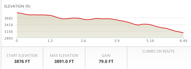
The total distance was 6.47 miles.
The hike was mostly downhill. Here is the elevation data:
I believe hiking and trail running are great ways to exercise, and a lot of people feel the same way. The challenge is fitting in a hike or a trail run when you have a busy schedule, especially during the week. Wouldn't it be nice if you could get off work, hike or run through beautiful groves of Oaks and Bay trees, and eat dinner in a grove of towering Eucalyptus trees?
It's a great place for a late afternoon hike, since the park closes at 8pm.
Here is a suggestion:
Pack a dinner. Either make something in advance, or bring something to barbecue. Kennedy Grove has grills, so you can have a cook out.
After work, drive to the park, pay the $5 parking fee, and take this hike. Either run it, or walk it at a steady pace. Even though the hike is short, the elevation change and the steep grade will make this a good workout. After the hike, relax and enjoy yourself in the picnic area. Groups can reserve picnic sections by calling 1-888-EBPARKS or 1-888-327-2757, and pressing option 2.
Note: Because of the steep grade, this hike is not recommended for small children or seriously deconditioned people. If you don't want to take this hike, the Black Oak Loop Trail is an easier alternative. (Trail Map Here)
Route Instructions:
Start out facing the picnic area. On your left is the where the trail starts. Basically, just walk through the grove of Eucalyptus trees and past the picnic tables and you'll see the trails in the back, left section of the park.
Once there (.20 miles) you'll see the Laurel Loop Trail on your right. Don't take that trail. Instead, keep going straight, past the big Oak tree.
At .24 miles you'll see the trail split in to a Y. On your right is the Lower Seafoam Trail. You'll be coming down that trail, but you want to bear left. This is the Kennedy Creek Trail. Kennedy Creek Trail is a wide, fire road type trail.
At .54 miles, you'll see a marker missing the trail signs. This is the start of Upper Sea Foam Trail. Take this trail (on the right) and start your climb. Upper Sea Foam quickly turns in to a narrow, single track trail.
At .78 miles, you'll be getting in to a beautiful section with lots of old, twisted Oaks, and great views of the reservoir.
1.07 miles, and you're at the peak of the climb. Here is a beautiful section of larger and older Oaks. Take a right and start your descent. As the trail descends, be very careful with your steps. It can be steep, so make sure your foot is firmly planted before taking another step. It may be helpful to bring a hiking stick. The loose dirt on top of the trail makes the steep descent even more challenging.
1.15 miles, enjoy a rest on the bench and take in the views.
At 1.20 miles, the trail splits again. Keep going straight, on to Lower Sea Foam Trail. The other direction is the Laurel Loop Trail. This section takes you through some old and towering Bay Trees.
At 1.47, you can hang out here, at this secret picnic table. There isn't a barbecue here, but it might be a nice place to rest and enjoy the forest.
At the end of the trail, keep left and head back to the park.
Total mileage, 1.81 miles. This is a short hike with some nice elevation change. If you have more time, look at the map and hike other trails in this park. This particular hike should take less than an hour to hike, and leave you some time for a nice dinner.
Mileage: 1.81 Miles Climb: 469 Feet Average Grade: 8.9% (Pretty steep)


 Baby Salmon hide under log jams for protection. The Marin Water District has created these artificial log jams to help protect the salmon.I walked along the creek to the dam, and then turned around and climbed up Shafter Grade. This is a nice hike, with views and the ability to go deep in to Marin Watershed lands, and ultimately to the coast.
 Keeping an eye on me.
 East Bay Trails